


Continental Drift Theory
Introduction
In 1908,
American geologist Frank B.Taylor
proposed that the continents were once joined together in a single landmass and
then drifted apart to their current positions. Taylor’s analysis of tectonic
features foreshadowed modern plate collision theory. In particular, he
suggested that the bow-shaped mountain belts of Asia and Europe were the result
of the continents creeping towards the equator.
Continental Drift Theory was put forward by the German scientist Alfred Wegner in 1912.
According to the
Continental Drift Theory, part of the crust are capable of horizontal movement
round the globe causing the continents to slowly change their positions in
relation to one another.
The fact that
South America is a mirror image of Africa is presented as a proof of the continental
drift theory.
For hundreds of
millions of years, all the land of Earth was joined together in one large mass
or super continent. Scientists call it Pangaea (meaning “all
lands” in Greek). Then about 200 million years ago the land began to drift
apart. It broke into two pieces, and scientists have called the continent in
the north Laurasia and the continent in the south Gondwanaland (named
by Eduard Suess, an Austrian geologist).The two large continents continued to
break apart into the smaller continents that exist today. Scientists call
this movement ‘continental drift’.

Assumptions of Continental Drift Theory by Alfred Wegner
Forces
responsible for drifting of continents (According to Alfred Wegner)
According to
Wegener, the drift was in two directions:
1. Towards the equator due to the interaction
of forces of gravity, pole-fleeing force (due to centrifugal
force caused by earth’s rotation) and buoyancy (ship floats
in water due to buoyant force offered by water)
2. Westwards due to tidal currents because
of the earth’s motion (earth rotates from west to east, so tidal currents act
from east to west, according to Wegener).
- Wegener suggested that tidal force (gravitational
pull of the moon and to a lesser extent, the sun) also played a major
role.
- The polar-fleeing force relates to the rotation of the earth. Earth is not a perfect
sphere; it has a bulge at the equator. This bulge is due to the rotation
of the earth (greater centrifugal force at the equator).
- Centrifugal force increases as we move from poles towards the equator. This
increase in centrifugal force has led to pole fleeing, according to
Wegener.
- Tidal force is due to the attraction of the moon
and the sun that develops tides in oceanic waters (tides explained in
detail in oceanography).
- According to Wegener, these forces would become
effective when applied over many million years, and the drift is
continuing.
The evidences in support of the continental drift theory:
Jigsaw Fit:
The similarity
in outline of the coastlines of eastern South America and West Africa had been
noted for some time. The best fit is obtained if the coastlines are matched at
a depth of 1,000 meters below current sea level.

Example:- The coastlines of many continents fit together like puzzle pieces, such as the coastlines of South America and Africa.
Geological Fit:
When the geology
of eastern South America and West Africa was mapped it revealed that ancient
rock outcrops (cratons) over 2,000 million years old were continuous from one
continent to the other.

Example:- resources of gold
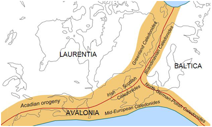
Tectonic Fit:
- Fragments of an old fold mountain belt between
450 and 400 million years ago are found on widely separated continents
today.
- Pieces of the Caledonian fold mountain belt are
found in Greenland, Canada, Ireland, England, Scotland and Scandinavia.
When these land masses are re-assembled the mountain, belt forms a
continuous linear feature.
Glacial Deposits:
- Today, glacial deposits formed during the
Permo-Carboniferous glaciation (about 300 million years ago) are found in
Antarctica, Africa, South America, India and Australia.
- If the continents haven’t moved, then this would
suggest an ice sheet extended from the South Pole to the equator at this
time – which is unlikely as the UK at this time was also close to the
equator and has extensive coal and limestone deposits.
- If the continents of the southern hemisphere are
re-assembled near the South Pole, then the Permo-Carboniferous ice sheet
assumes a much more reasonable size

Fossil Evidence:
- There are many examples of fossils found on
separate continents and nowhere else, suggesting the continents were once
joined. If Continental Drift had not occurred, the alternative
explanations would be:
- The species evolved independently on separate
continents – contradicting Darwin’s theory of evolution.
- They swam to the other continent/s in breeding
pairs to establish a second population.
Example:- Fossils of the same species
have been found on opposite sides of oceans.

- Wegener failed to explain why the drift began only in Mesozoic era and not before.
- The theory doesn’t consider oceans.
- Proofs heavily depend on assumptions that are generalist.
- Forces like buoyancy, tidal currents and gravity are too weak to be able to move continents.
- Modern theories (Plate Tectonics) accept the existence of Pangaea and related landmasses but give a very different explanation to the causes of drift.
